Monday, 27 July 2015


Monday, 20 July 2015

Wednesday, 8 July 2015


MUNNAR ,IDUKKI ,KERALA, INDIA. PRAVEEN C R PHOTOGRAPHY Most of the native flora and fauna of Munnar have disappeared due to severe habitat fragmentation resultant from the creation of the plantations. However, some species continue to survive and thrive in several protected areas nearby, including the new Kurinjimala Sanctuary to the east, the Chinnar Wildlife Sanctuary, Manjampatti Valley and the Amaravati reserve forest of Indira Gandhi Wildlife Sanctuary to the north east, the Eravikulam National Park and Anamudi Shola National Park to the north, the Pampadum Shola National Park to the south and the proposed Palani Hills National Park to the east.

TAJ MAHAL, PRAVEEN C RPHOTOGRAPHY The Taj Mahal is regarded by many as the best example of Mughal architecture and is widely recognized as "the jewel of Muslim art in India". It is one of the world’s most celebrated structures and a symbol of India’s rich history. Designated a UNESCO World Heritage Site in 1983, the Taj Mahal attracts some 3 million visitors a year.

Taj Mahal, INDIA, PRAVEEN C R PHOTOGRAPHY,The Taj Mahal (/ˌtɑːdʒ məˈhɑːl/, more often /ˈtɑːʒ/;[2] from Persian and Arabic, "crown of palaces", pronounced [ˈt̪aːdʒ mɛˈɦɛl]) is a white marble mausoleum located on the southern bank of Yamuna River in the Indian city of Agra. It was commissioned in 1632 by the Mughal emperor Shah Jahan (reigned 1628–1658) to house the tomb of his favorite wife of three, Mumtaz Mahal.

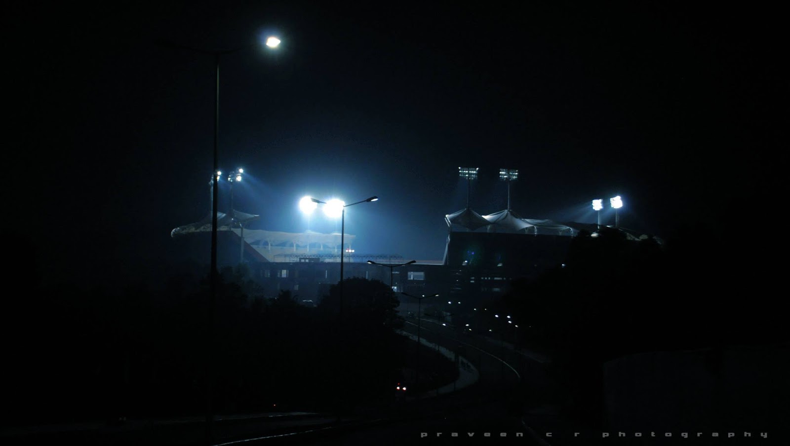
Trivandrum International Stadium ,INDIA ,PRAVEEN C RPHOTOGRAPHY Trivandrum International Stadium or Greenfield Stadium is a multi-purpose stadium in Kerala. The stadium is located at Kariavattom, a suburb of Thiruvananthapuram in Kerala, India.[2] It is India's first DBOT (design, build, operate and transfer) model outdoor stadium.


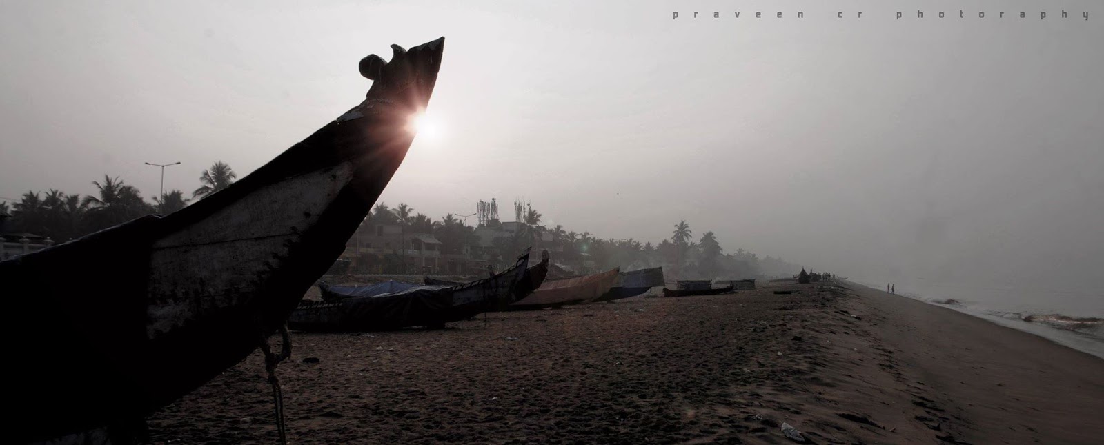
SHANGUMUGAM BEACH ,KERALA,INDIA, PRAVEEN C R PHOTOGRAPHY Shankumugham Beach is a beach in Thiruvananthapuram district of Kerala, south India. The beach is on the western side of Thiruvananthapuram (Trivandrum) city and very near to Trivandrum International Airport. The vast stretch of white sand and the serene atmosphere, away from the crowd in the city, provide all the ingredients for relaxation and for spending an ideal evening. There is also a “Star Fish Restaurant” with eating kiosks and open-air theatre with car parking facilities. Good food can be enjoyed at the Indian Coffee House, just across the beach, which is also a vantage point for enjoying the sunset. Unfortunately, the beach is not well maintained with garbage littering the entire area.

SHANGUMUGHAM,KERALA,INDIA, PRAVEEN C R PHOTOGRAPHY Shankumugham Beach is a beach in Thiruvananthapuram district of Kerala, south India. The beach is on the western side of Thiruvananthapuram (Trivandrum) city and very near to Trivandrum International Airport. The vast stretch of white sand and the serene atmosphere, away from the crowd in the city, provide all the ingredients for relaxation and for spending an ideal evening. There is also a “Star Fish Restaurant” with eating kiosks and open-air theatre with car parking facilities. Good food can be enjoyed at the Indian Coffee House, just across the beach, which is also a vantage point for enjoying the sunset. Unfortunately, the beach is not well maintained with garbage littering the entire area.

MANALI,INDIA,PRAVEEN C R PHOTOGRAPHY Manali is a small town; as of the 2011 census of India, its population was 8,096.[1] In 2001,[2] Manali had an official population of 6,265. Males constituted 64% of the population and females 36%. Manali had an average literacy rate of 74%, higher than the national average of 59.5%; male literacy was 80%, and female literacy was 63%. 9% of the population was under six years of age.

MANALI,INDIA,PRAVEEN CR PHOTOGRAPHY The climate in Manali is predominantly cold during winters, and moderately cool during summers. The temperatures range from 4 °C (39 °F) to 20 °C (68 °F) over the year. The average temperature during summer is between 04 °C (39 °F) and 15 °C (59 °F), and between −15 °C (5 °F) and 05 °C (41 °F) in the winter.


MANALI,INDIA PRAVEEN C R PHOTOGRAPHY Manali (Hindi: मनाली) is a hill station nestled in the mountains of the Indian state of Himachal Pradesh near the northern end of the Kullu Valley, at an altitude of 2,050 m (6,726 ft) in the Beas River Valley. It is located in the Kullu district, about 270 km (168 mi) north of the state capital, Shimla. The small town, with a population of 8,096,[1] is the beginning of an ancient trade route to Ladakh and from there over the Karakoram Pass on to Yarkand and Khotan in the Tarim Basin. It has become a tourist attraction in recent years.

MANALI,INDIA / PRAVEEN C R PHOTOGRAPHY Manali (Hindi: मनाली) is a hill station nestled in the mountains of the Indian state of Himachal Pradesh near the northern end of the Kullu Valley, at an altitude of 2,050 m (6,726 ft) in the Beas River Valley. It is located in the Kullu district, about 270 km (168 mi) north of the state capital, Shimla. The small town, with a population of 8,096,[1] is the beginning of an ancient trade route to Ladakh and from there over the Karakoram Pass on to Yarkand and Khotan in the Tarim Basin. It has become a tourist attraction in recent years.

MUNNAR,KERALA,INDIA/ PRAVEEN CR PHOTOGRAPHY /Munnar (Malayalam: മൂന്നാർ) is a town and hill station located in the Idukki district of the southwestern Indian state of Kerala. Munnar is situated at around 1,600 metres (5,200 ft) above sea level,[2] in the Western Ghats range of mountains. The name Munnar is believed to mean "three rivers",[3] referring to its location at the confluence of the Mudhirapuzha, Nallathanni and Kundaly rivers.[4] Munnar town is situated on the Kannan Devan Hills village in Devikulam taluk and is the largest panchayat in the Idukki district covering an area of nearly 557 square kilometres (215 sq mi).[citation needed] The nearest major railway stations are at Ernakulam and Aluva (approximately 140 kilometres (87 mi) by road). The nearest airport is Cochin International Airport, which is 105 kilometres (65 mi) away.

Subscribe to:
Posts (Atom)